Scientists Develop AI Tool That Generates Realistic Satellite Images of Future Flooding

Scientists have developed a new AI tool that lets users generate realistic satellite images of future flooding and prepare for approaching storms.
Massachusetts Institute of Technology (MIT) scientists developed the groundbreaking AI tool that uses satellite imagery to predict the impact of future flooding.
By combining generative AI with a physics-based flood model, the tool — which is called the “Earth Intelligence Engine” creates realistic aerial images that depict how a region would look after a potential flooding event.
The images “from the future” show where flooding is likely to occur given the strength of an oncoming storm.
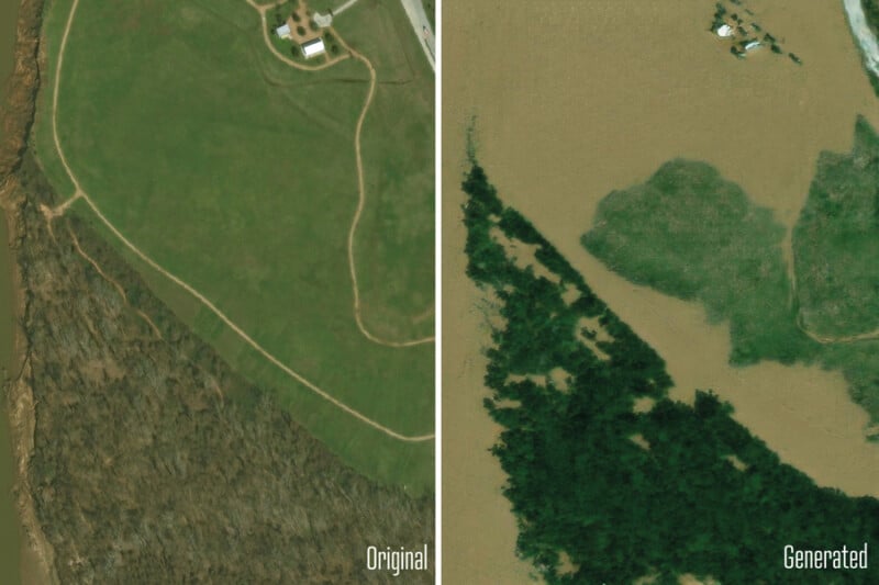
According to an MIT news release, the team applied the method to Houston as a test case and generated satellite images depicting what certain locations around the city would look like after a storm comparable to Hurricane Harvey in 2017.
The team compared these generated images with actual satellite images taken of the same regions after Harvey hit. They also analyzed AI-generated images that did not incorporate a physics-based flood model.
The team’s physics-enhanced approach produced satellite images of future flooding that were both more realistic and accurate. In contrast, the AI-only method created flood images in areas where flooding is physically impossible.
To apply this method to other regions, the AI tool will require training on a significantly larger dataset of satellite images to understand how flooding manifests in different areas.
The MIT researchers revealed the results of the AI tool in a study published in the journal IEEE Transactions on Geoscience and Remote Sensing this month. The team has also made the Earth Intelligence Engine available as an online resource for others to try.
“The idea is: One day, we could use this before a hurricane, where it provides an additional visualization layer for the public,” Björn Lütjens, a postdoctoral researcher in MIT’s Department of Earth, Atmospheric and Planetary Sciences, says in a statement.
“One of the biggest challenges is encouraging people to evacuate when they are at risk. Maybe this could be another visualization to help increase that readiness.”
Image credits: All photos via Massachusetts Institute of Technology (MIT).


